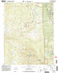
2004 Map of North Fork
USGS Topo · Published 2007About this map
Sierra National Forest lands dominate this central California landscape, where the foothills of the Sierra Nevada meet established settlements like North Fork. The map documents a blend of mid-century infrastructure and older rural markers, featuring the Fresno Banner Mine and a Landing Strip near the Joaquin River. Water management is central to the area's development, evidenced by the Kerckhoff Dam and the resulting waters of Kerckhoff Lake at the southern edge of the quadrangle. Local genealogy is supported by the presence of North Fork Cemetery, Walker Cem, and another smaller Cem near the forest boundary. Residential clusters ranging from the historical Old Town to the Shady Oaks Mobile Park illustrate the evolving housing patterns in Madera County during the early 21st century. The terrain is deeply carved by watercourses such as Fine Gold Creek and Gold Fine Creek, which flow through named flats and canyons like Ironton Flats and Grapevine Canyon.
Find a feature on this map
41 named features on this map. Tap any name to fly to it.
Don’t see what you’re looking for? This feature index may not catch every label — zoom into the map to look around manually.
Map Details
Editions of this 2004 North Fork Map
This is the sole edition of this map. No revisions or reprints were ever made.
Other maps of this area

1904 · Kaiser
USGS Topo · 1:125,000

1912 · Mariposa
USGS Topo · 1:125,000

1916 · Sulphur Springs
USGS Topo · 1:24,000

1919 · Sulphur Springs
USGS Topo · 1:31,680

1942 · Millerton Lake
USGS Topo · 1:62,500

1945 · Millerton Lake
USGS Topo · 1:62,500

1947 · Mariposa
USGS Topo · 1:250,000

1948 · Mariposa
USGS Topo · 1:250,000
1953 · Bass Lake
USGS Topo · 1:62,500

1953 · Shaver Lake
USGS Topo · 1:62,500