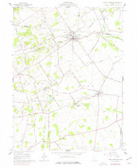
1961 Map of North Lewisburg
USGS Topo · Published 1977About this map
The village of North Lewisburg and its surrounding townships define this mid-century look at Champaign and Union counties. The landscape is marked by a legacy of rural infrastructure, where the Erie-Lackawanna and Pennsylvania railroads intersect the farm-to-market road network. Genealogists will find a wealth of family-named landmarks and resting places, from the Sodom Cem in the south to the Graham Cem near the Logan County line. Significant religious and educational hubs, such as the Immaculate Conception Ch and the Triad High Sch, reflect the community's centers of life during the late 1950s and early 1960s.
Find a feature on this map
70 named features on this map. Tap any name to fly to it.
Don’t see what you’re looking for? This feature index may not catch every label — zoom into the map to look around manually.
Map Details
Editions of this 1961 North Lewisburg Map
Other maps of this area

1913 · East Liberty
USGS Topo · 1:62,500

1913 · Richwood
USGS Topo · 1:62,500

1914 · Mechanicsburg
USGS Topo · 1:62,500

1915 · Richwood
USGS Topo · 1:62,500

1915 · East Liberty
USGS Topo · 1:62,500

1916 · Mechanicsburg
USGS Topo · 1:62,500

1916 · Milford Center
USGS Topo · 1:62,500

1944 · East Liberty
USGS Topo · 1:62,500

1944 · Mechanicsburg
USGS Topo · 1:62,500

1944 · Richwood
USGS Topo · 1:62,500