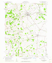
1961 Map of North Lewisburg
USGS Topo · Published 1962About this map
The village of North Lewisburg serves as a focal point for this agrarian landscape in the early 1960s, situated at the junction of several townships including Zane, Wayne, and Rush. The area is defined by a dense network of country roads and family cemeteries, such as Butcher Cem and Maple Grove Cem, reflecting generations of local settlement. Two major rail corridors, the Erie-Lackawanna and the Pennsylvania, cross the territory, connecting rural hubs like Woodstock and Middletown to broader markets.
Find a feature on this map
44 named features on this map. Tap any name to fly to it.
Don’t see what you’re looking for? This feature index may not catch every label — zoom into the map to look around manually.
Map Details
Editions of this 1961 North Lewisburg Map
Other maps of this area

1913 · East Liberty
USGS Topo · 1:62,500

1913 · Richwood
USGS Topo · 1:62,500

1914 · Mechanicsburg
USGS Topo · 1:62,500

1915 · Richwood
USGS Topo · 1:62,500

1915 · East Liberty
USGS Topo · 1:62,500

1916 · Mechanicsburg
USGS Topo · 1:62,500

1916 · Milford Center
USGS Topo · 1:62,500

1944 · East Liberty
USGS Topo · 1:62,500

1944 · Mechanicsburg
USGS Topo · 1:62,500

1944 · Richwood
USGS Topo · 1:62,500