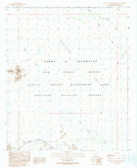
1990 Map of North of Agua Dulce Mountains
USGS Topo · Published 1990About this map
Chinaman Flat lies at the southern edge of this desert expanse, a rare named low-lying area within a landscape defined by drainage patterns and military boundaries. The terrain is dominated by the broad, sweeping basin of Growler Valley, where the ephemeral courses of San Cristobal Wash and Growler Wash traverse the arid floor. These dry watercourses highlight the hydrological character of the Sonoran Desert, feeding into a basin where the only artificial water source noted is Redtail Tank in the north.
Find a feature on this map
15 named features on this map. Tap any name to fly to it.
Don’t see what you’re looking for? This feature index may not catch every label — zoom into the map to look around manually.
Map Details
Editions of this 1990 North of Agua Dulce Mountains Map
This is the sole edition of this map. No revisions or reprints were ever made.
Other maps of this area

1953 · Ajo
USGS Topo · 1:250,000

1957 · Ajo
USGS Topo · 1:250,000

1958 · Ajo
USGS Topo · 1:250,000

1962 · Ajo
USGS Topo · 1:250,000

1963 · Ajo
USGS Topo · 1:250,000

1964 · Growler Peak
USGS Topo · 1:62,500
1964 · Agua Dulce Mts
USGS Topo · 1:62,500

1965 · O'Neill Hills
USGS Topo · 1:62,500

1965 · Granite Mountains
USGS Topo · 1:62,500

1967 · Ajo
USGS Topo · 1:250,000