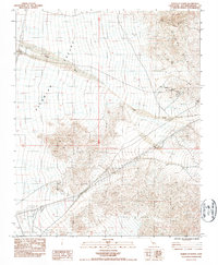
1983 Map of North of Baker
USGS Topo · Published 1985About this map
Silurian Valley dominates this arid landscape of the Mojave, showing a region defined by industrial extraction and former transportation corridors. The wide Riggs Wash cuts through the center of the sheet, while the northern extent of the Silurian Hills and Owl Canyon rise to the east. For historians, the map reveals a layer of industrial history through the Silver Lake Mines and numerous Prospects scattered across the uplands. Human presence is sparse, centered on the Riggs area and the Talc (Site), connected by an Old Railroad Grade that traces the valley floor. Modern utility infrastructure is also evident, with Steel Tower Transmission Lines and a Substation cutting across the desert flats south of the primary mining zones.
Find a feature on this map
14 named features on this map. Tap any name to fly to it.
Don’t see what you’re looking for? This feature index may not catch every label — zoom into the map to look around manually.
Map Details
Editions of this 1983 North of Baker Map
2 editions found
Other maps of this area

1910 · Ivanpah
USGS Topo · 1:250,000

1912 · Ivanpah
USGS Topo · 1:250,000

1933 · Avawatz Mountains
USGS Topo · 1:250,000

1942 · Ivanpah
USGS Topo · 1:250,000

1947 · Trona
USGS Topo · 1:250,000

1947 · Kingman
USGS Topo · 1:250,000

1948 · Kingman
USGS Topo · 1:250,000

1948 · Trona
USGS Topo · 1:250,000

1953 · Trona
USGS Topo · 1:250,000

1954 · Kingman
USGS Topo · 1:250,000