1994 Map of North Powder
USGS Topo · Published 1994About this map
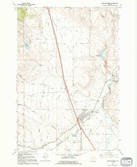
North Powder sits at the heart of this agricultural and riparian landscape along the Powder River, marking the boundary between Union and Baker counties. The town's grid is flanked by significant water management features, including the Sewage Disposal Ponds and the nearby North Powder Pond No 1, which reflect the infrastructure of the late twentieth century. To the east, the Dorion Historical Marker stands near the river, anchoring the area's local heritage.
Find a feature on this map
36 named features on this map. Tap any name to fly to it.
Don’t see what you’re looking for? This feature index may not catch every label — zoom into the map to look around manually.
Map Details
Editions of this 1994 North Powder Map
This is the sole edition of this map. No revisions or reprints were ever made.
Other maps of this area

1901 · Baker City
USGS Topo · 1:125,000

1901 · Sumpter
USGS Topo · 1:125,000

1906 · Telocaset
USGS Topo · 1:125,000

1953 · Pendleton
USGS Topo · 1:250,000

1955 · Baker
USGS Topo · 1:250,000

1955 · Grangeville
USGS Topo · 1:250,000

1955 · Canyon City
USGS Topo · 1:250,000

1956 · Pendleton
USGS Topo · 1:250,000

1959 · Baker
USGS Topo · 1:250,000

1959 · Grangeville
USGS Topo · 1:250,000