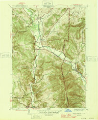
1946 Map of North Pownal
USGS Topo · Published 1946About this map
The Hoosic River carves a deep valley through the Taconic Mountains, serving as the primary corridor for commerce and settlement along the New York and Vermont border. In the mid-1940s, this landscape is defined by its strategic rail connections, where the Rutland and Boston and Maine railroads intersect at Petersburg Junction. This junction was a vital transshipment point, linking the agricultural and industrial outputs of the valley to larger regional markets. Away from the river, the terrain rises sharply into numerous named hollows, such as Ellis Mine Hollow and Breese Hollow, reflecting a legacy of localized mountain industry and family farming. Small rural schoolhouses like School No 11 and School No 3 remain scattered across the highlands, while the village of North Pownal sits nestled in the eastern bend of the river under the shadow of the state line.
Find a feature on this map
39 named features on this map. Tap any name to fly to it.
Don’t see what you’re looking for? This feature index may not catch every label — zoom into the map to look around manually.
Map Details
Editions of this 1946 North Pownal Map
2 editions found
Other maps of this area

1886 · Greylock
USGS Topo · 1:62,500

1888 · Berlin
USGS Topo · 1:62,500

1890 · Berlin
USGS Topo · 1:62,500

1891 · Greylock
USGS Topo · 1:62,500

1893 · Greylock
USGS Topo · 1:62,500

1894 · Berlin
USGS Topo · 1:62,500

1897 · Hoosick
USGS Topo · 1:62,500

1898 · Berlin
USGS Topo · 1:62,500

1898 · Bennington
USGS Topo · 1:62,500

1898 · Greylock
USGS Topo · 1:62,500