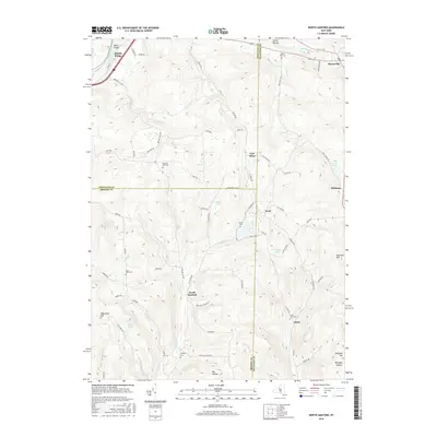
2016 Map of North Sanford
USGS Topo · Published 2016About this map
North Sanford and the surrounding borderlands of Chenango, Delaware, and Broome counties define this rural landscape. The Susquehanna River cuts through the northwest corner near Middle Bridge, while a network of creeks including Oquaga Cr and Cold Spring Cr drain the high ground. Small crossroads settlements like Arctic and China anchor the eastern ridges, connected by winding routes such as Co Rd 20 and N Sanford Rd. For genealogists, the map is remarkably dense with burial sites, identifying numerous family-named and local graveyards including Beech Hill Cem, Melondy Hill Cem, and the Lord Road Cem. The terrain is marked by significant elevations like Burnside Hill and Michigan Hill, reflecting the traditional farming and woodlot economy of the Southern Tier.
Find a feature on this map
72 named features on this map. Tap any name to fly to it.
Don’t see what you’re looking for? This feature index may not catch every label — zoom into the map to look around manually.
Map Details
Editions of this 2016 North Sanford Map
This is the sole edition of this map. No revisions or reprints were ever made.
Other maps of this area

1902 · Coventry
USGS Topo · 1:62,500

1904 · Oxford
USGS Topo · 1:62,500

1905 · Nineveh
USGS Topo · 1:62,500

1915 · Unadilla
USGS Topo · 1:62,500

1918 · Unadilla
USGS Topo · 1:62,500

1924 · Deposit
USGS Topo · 1:62,500

1926 · Deposit
USGS Topo · 1:62,500

1943 · Sidney
USGS Topo · 1:24,000
1943 · Unadilla
USGS Topo · 1:24,000

1944 · Deposit
USGS Topo · 1:62,500