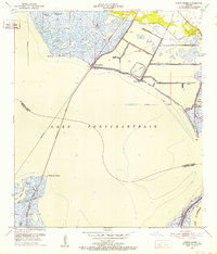
1951 Map of North Shore
USGS Topo · Published 1952About this map
Lake Pontchartrain dominates this early 1950s survey, illustrating the complex relationship between the water and the low-lying settlements of St. Tammany Parish. The community of North Shore serves as a focal point where the Southern railroad meets a long Bridge spanning the open water, a critical transportation artery of the era. To the east, the small coastal cluster at Howze Beach is situated near Grand Lagoon, while the northern interior shows a landscape heavily modified by a series of numbered canals, such as Canal No 1 and Canal No 4, which were vital for drainage and navigation through the marsh. Further inland, the map identifies Fields Cem and the settlement of Guzman. The boundary between St. Tammany and Orleans Parish cuts through the marshlands, marking the transition into the wetlands surrounding Irish Bayou and Bayou de la Pointe aux Herbes.
Find a feature on this map
31 named features on this map. Tap any name to fly to it.
Don’t see what you’re looking for? This feature index may not catch every label — zoom into the map to look around manually.
Map Details
Editions of this 1951 North Shore Map
2 editions found
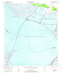
Other maps of this area

1892 · Chef Menteur
USGS Topo · 1:62,500

1893 · Rigolets
USGS Topo · 1:62,500

1914 · Nicholson
USGS Topo · 1:62,500

1921 · Nicholson
USGS Topo · 1:62,500

1935 · Slidell
USGS Topo · 1:62,500

1936 · North Shore
USGS Topo · 1:31,680

1936 · South Point
USGS Topo · 1:31,680

1936 · Chef Menteur
USGS Topo · 1:62,500

1936 · Rigolets
USGS Topo · 1:62,500

1937 · Chef Menteur
USGS Topo · 1:31,680