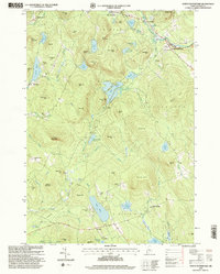
1995 Map of North Waterford
USGS Topo · Published 2000About this map
North Waterford sits at the junction of the Crooked River and several historic roadways, serving as a hub for the scattered settlements of Albany, Stoneham, Lovell, and Sweden during the mid-1990s. The landscape is defined by its numerous water bodies and small hilltop communities, from the northern clusters of North Lovell and Lynchville to the southern reach of Sweden. The area’s genealogical record is well-preserved through several small burial grounds including Hillside Cemetery, Woodlawn Cemetery, and Brackett Cemetery. Evidence of the region’s economic and social activity is visible in the presence of several Gravel Pit locations and the Fairgrounds near North Waterford. The rugged geography, marked by peaks such as Sabattus Mountain and Allen Mountain, dictates the winding paths of the Kezar River and Patterson Brook, illustrating how the terrain shaped the early roads and property boundaries of Oxford County.
Find a feature on this map
83 named features on this map. Tap any name to fly to it.
Don’t see what you’re looking for? This feature index may not catch every label — zoom into the map to look around manually.
Map Details
Editions of this 1995 North Waterford Map
This is the sole edition of this map. No revisions or reprints were ever made.
Other maps of this area

1896 · Norway
USGS Topo · 1:62,500

1909 · Fryeburg
USGS Topo · 1:62,500

1911 · Fryeburg
USGS Topo · 1:62,500

1911 · Bryant Pond
USGS Topo · 1:62,500

1914 · Bethel
USGS Topo · 1:62,500

1914 · Bryant Pond
USGS Topo · 1:62,500

1940 · Bethel
USGS Topo · 1:62,500

1941 · Bethel
USGS Topo · 1:62,500

1941 · Fryeburg
USGS Topo · 1:62,500

1942 · Bryant Pond
USGS Topo · 1:62,500