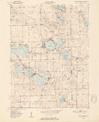
1950 Map of North Webster
USGS Topo · Published 1952About this map
Webster Lake and the town of North Webster sit at the heart of this post-war lake district, where the intricate drainage of the Tippecanoe watershed forms a dense network of glacial basins. The landscape is defined by its recreational and religious encampments, including Epworth Forest on the northern shore of Webster Lake and a cluster of institutional sites such as Camp Tippecanoe, Camp Dick Runyan, and Camp Crosley. This 1950s survey captures the region as a primary destination for summer retreats and youth camps before modern shoreline densification.
Find a feature on this map
69 named features on this map. Tap any name to fly to it.
Don’t see what you’re looking for? This feature index may not catch every label — zoom into the map to look around manually.
Map Details
Editions of this 1950 North Webster Map
2 editions found
Other maps of this area

1950 · Leesburg
USGS Topo · 1:24,000

1950 · Pierceton
USGS Topo · 1:24,000

1950 · North Webster
USGS Topo · 1:24,000

1951 · Milford
USGS Topo · 1:24,000

1951 · Wawasee
USGS Topo · 1:24,000

1951 · Ormas
USGS Topo · 1:24,000

1953 · Fort Wayne
USGS Topo · 1:250,000

1956 · Fort Wayne
USGS Topo · 1:250,000

1956 · Ligonier
USGS Topo · 1:24,000

1956 · Lorane
USGS Topo · 1:24,000