
1945 Map of Northfield
USGS Topo · Published 1958About this map
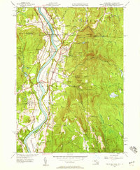
The Connecticut River carves a deep valley through this borderland region, where the boundaries of Massachusetts, New Hampshire, and Vermont converge. In the mid-1940s, the landscape is defined by its educational institutions and extensive meadowlands, including Pauchaug Meadow and Beers Plain. The educational hubs of Northfield Seminary and the Mt Hermon School dominate the banks of the river, connected by regional infrastructure like the Schell Bridge and the Bennett Meadow Bridge.
Find a feature on this map
113 named features on this map. Tap any name to fly to it.
Don’t see what you’re looking for? This feature index may not catch every label — zoom into the map to look around manually.
Map Details
Editions of this 1945 Northfield Map
2 editions found
Other maps of this area

1887 · Warwick
USGS Topo · 1:62,500

1889 · Warwick
USGS Topo · 1:62,500

1890 · Greenfield
USGS Topo · 1:62,500

1891 · Brattleboro
USGS Topo · 1:62,500

1893 · Brattleboro
USGS Topo · 1:62,500

1894 · Greenfield
USGS Topo · 1:62,500

1894 · Warwick
USGS Topo · 1:62,500

1898 · Keene
USGS Topo · 1:62,500

1932 · Brattleboro
USGS Topo · 1:48,000

1932 · Warwick
USGS Topo · 1:48,000