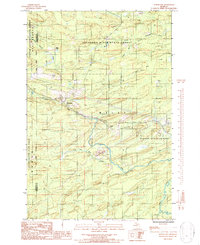
1986 Map of Northland
USGS Topo · Published 1986About this map
Northland sits at the heart of this mid-1980s survey, a small settlement positioned near the confluence of local waterways in Marquette County. The landscape is defined by the convergence of the Copper Country State Forest and the Escanaba River State Forest, where dense forest boundaries meet the winding paths of the Ford River and Escanaba River. This period of Michigan's Upper Peninsula history shows a region primarily shaped by natural resource management and transit, with a Pipeline and Transmission Line cutting a diagonal path across the woodland.
Find a feature on this map
23 named features on this map. Tap any name to fly to it.
Don’t see what you’re looking for? This feature index may not catch every label — zoom into the map to look around manually.
Map Details
Editions of this 1986 Northland Map
This is the sole edition of this map. No revisions or reprints were ever made.
Other maps of this area

1932 · Helena NW
USGS Topo · 1:31,680

1932 · Helena SW
USGS Topo · 1:31,680

1951 · Helena SW
USGS Topo · 1:31,680

1951 · Helena NW
USGS Topo · 1:31,680

1954 · Escanaba
USGS Topo · 1:250,000

1956 · Foster City
USGS Topo · 1:62,500

1957 · Escanaba
USGS Topo · 1:250,000

1957 · Northland
USGS Topo · 1:62,500

1958 · Escanaba
USGS Topo · 1:250,000

1958 · Marquette
USGS Topo · 1:250,000