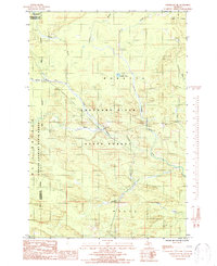
1986 Map of Northland NE
USGS Topo · Published 1987About this map
The Escanaba River and its West Branch dominate this remote northern Michigan landscape, where the waters converge within the protected boundaries of the Escanaba River State Forest and Copper Country State Forest. This 1980s-era survey reveals a terrain defined by its drainage network, including Landon Lake and numerous tributary streams like Bryan Creek, Chandler Creek, and Miller Creek. The boundary between Marquette and Dickinson counties bisects the western half of the map, illustrating the jurisdictional lines that cut through these vast timberlands. While primarily a wilderness of state-managed forest, industrial activity is marked by a Gravel Pit and a network of unimproved roads and trails. These paths, alongside named water bodies like Gleason Creek and Chynes Creek, provide critical landmarks for those navigating the Upper Peninsula's interior.
Find a feature on this map
18 named features on this map. Tap any name to fly to it.
Don’t see what you’re looking for? This feature index may not catch every label — zoom into the map to look around manually.
Map Details
Editions of this 1986 Northland NE Map
This is the sole edition of this map. No revisions or reprints were ever made.
Other maps of this area

1932 · Helena NW
USGS Topo · 1:31,680

1932 · Harvey SW
USGS Topo · 1:31,680

1932 · Helena SW
USGS Topo · 1:31,680

1951 · Helena SW
USGS Topo · 1:31,680

1951 · Helena NW
USGS Topo · 1:31,680

1952 · Ishpeming
USGS Topo · 1:62,500

1952 · Gwinn
USGS Topo · 1:62,500

1952 · Gwinn
USGS Topo · 1:24,000

1957 · Northland
USGS Topo · 1:62,500

1958 · Marquette
USGS Topo · 1:250,000
Featured Places
- Forsyth Township, MI
- West Branch Township, MI
- Tilden Township, MI
- Wells Township, MI
- Marquette County, MI