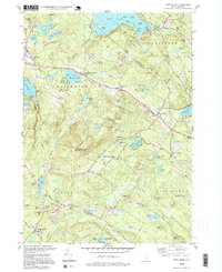
1995 Map of Northwood
USGS Topo · Published 2000About this map
Saddleback Mountain rises as a central landmark in this region of southern New Hampshire, overlooking a landscape defined by glacial lakes and small village clusters. In the mid-1990s, the chain of settlements along the primary corridor includes Northwood Narrows, Northwood Center, and Northwood Ridge, illustrating the historical development of transit-oriented hamlets in Rockingham and Strafford counties. To the north, Bow Lake and its many islands, such as Loon Island and Pine Island, serve as focal points for recreation, evidenced by numerous boat ramps and camps like Camp Wab-Tut-Ca.
Find a feature on this map
89 named features on this map. Tap any name to fly to it.
Don’t see what you’re looking for? This feature index may not catch every label — zoom into the map to look around manually.
Map Details
Editions of this 1995 Northwood Map
This is the sole edition of this map. No revisions or reprints were ever made.
Other maps of this area

1917 · Mt. Pawtuckaway
USGS Topo · 1:62,500

1919 · Mt. Pawtuckaway
USGS Topo · 1:62,500

1919 · Gilmanton
USGS Topo · 1:62,500

1919 · Alton
USGS Topo · 1:62,500

1921 · Suncook
USGS Topo · 1:62,500

1927 · Gilmanton
USGS Topo · 1:62,500

1939 · Mt. Pawtuckaway
USGS Topo · 1:62,500

1944 · Mt. Pawtuckaway
USGS Topo · 1:62,500

1944 · Suncook
USGS Topo · 1:62,500

1949 · Portland
USGS Topo · 1:250,000