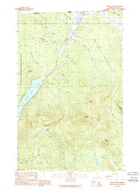
1989 Map of Norton Pond
USGS Topo · Published 1989About this map
The northern edge of Essex County meets the international border with Canada in this late 1980s topographical record. The settlement of Norton serves as the focal point, situated near the headwaters of the Coaticook River. This landscape is defined by its water and high peaks, including Gore Mountain and Round Mountain, which dominate the central terrain. South of the town, the large expanse of Norton Pond provides a significant landmark, while the Bill Sladyk State Wildlife Management Area covers much of the western map area.
Find a feature on this map
41 named features on this map. Tap any name to fly to it.
Don’t see what you’re looking for? This feature index may not catch every label — zoom into the map to look around manually.
Map Details
Editions of this 1989 Norton Pond Map
This is the sole edition of this map. No revisions or reprints were ever made.
Other maps of this area

1924 · Island Pond
USGS Topo · 1:48,000

1926 · Island Pond
USGS Topo · 1:62,500

1929 · Averill
USGS Topo · 1:62,500

1949 · Jackman
USGS Topo · 1:250,000

1950 · Lewiston
USGS Topo · 1:250,000

1953 · Island Pond
USGS Topo · 1:62,500

1953 · Averill
USGS Topo · 1:62,500

1956 · Lewiston
USGS Topo · 1:250,000

1961 · Lewiston
USGS Topo · 1:250,000

1962 · Lewiston
USGS Topo · 1:250,000