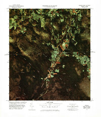
1978 Map of Norton Port of Entry
USGS Topo · Published 1978About this map
The Norton Port of Entry U S Customs serves as the focal point of this international border landscape, where the Vermont settlement of Norton meets its Quebec counterpart, Stanhope. The map illustrates a corridor defined by the Canadian National railroad and the Coaticook River, which winds northward across the Canada United States boundary. This 1978 color image map reveals the precise intersection of international commerce and the natural environment, showing how the local road network and rail line are funneled through this specific geographic pass.
Find a feature on this map
17 named features on this map. Tap any name to fly to it.
Don’t see what you’re looking for? This feature index may not catch every label — zoom into the map to look around manually.
Map Details
Editions of this 1978 Norton Port of Entry Map
This is the sole edition of this map. No revisions or reprints were ever made.
Other maps of this area

1924 · Island Pond
USGS Topo · 1:48,000

1926 · Island Pond
USGS Topo · 1:62,500

1929 · Averill
USGS Topo · 1:62,500

1949 · Jackman
USGS Topo · 1:250,000

1950 · Lewiston
USGS Topo · 1:250,000

1953 · Island Pond
USGS Topo · 1:62,500

1953 · Averill
USGS Topo · 1:62,500

1956 · Lewiston
USGS Topo · 1:250,000

1961 · Lewiston
USGS Topo · 1:250,000

1962 · Lewiston
USGS Topo · 1:250,000