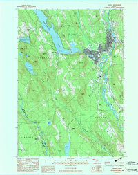
1983 Map of Norway
USGS Topo · Published 1983About this map
Pennesseewassee Lake dominates the northern landscape of this region, serving as a focal point for the settlements of Norway Lake and Norway. The twin village centers of Norway and South Paris are tightly clustered near the falls of the Little Androscoggin River, where the Canadian National railroad tracks cut through the river valley. This geography highlights the late 20th-century transition of the area from a water-powered industrial hub to a residential and recreational corridor.
Find a feature on this map
58 named features on this map. Tap any name to fly to it.
Don’t see what you’re looking for? This feature index may not catch every label — zoom into the map to look around manually.
Map Details
Editions of this 1983 Norway Map
This is the sole edition of this map. No revisions or reprints were ever made.
Other maps of this area

1896 · Norway
USGS Topo · 1:62,500

1908 · Poland
USGS Topo · 1:62,500

1911 · Bryant Pond
USGS Topo · 1:62,500

1911 · Buckfield
USGS Topo · 1:62,500

1913 · Buckfield
USGS Topo · 1:62,500

1914 · Bryant Pond
USGS Topo · 1:62,500

1940 · Poland
USGS Topo · 1:62,500

1942 · Buckfield
USGS Topo · 1:62,500

1942 · Bryant Pond
USGS Topo · 1:62,500

1942 · Poland
USGS Topo · 1:62,500