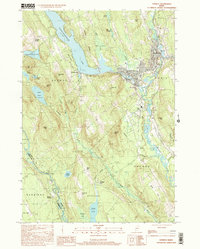
2000 Map of Norway
USGS Topo · Published 2001About this map
The town of Norway and the adjacent village of South Paris serve as the primary population centers in this Maine interior landscape at the opening of the 21st century. The geography is defined by significant water bodies, most notably Pennesseewassee Lake, which is bordered by a State Park, and the winding course of the Little Androscoggin River. The map reveals a community structured around its natural water resources, with settlements like Norway Center and Norway Lake punctuating the wooded hills.
Find a feature on this map
57 named features on this map. Tap any name to fly to it.
Don’t see what you’re looking for? This feature index may not catch every label — zoom into the map to look around manually.
Map Details
Editions of this 2000 Norway Map
This is the sole edition of this map. No revisions or reprints were ever made.
Other maps of this area

1896 · Norway
USGS Topo · 1:62,500

1908 · Poland
USGS Topo · 1:62,500

1911 · Bryant Pond
USGS Topo · 1:62,500

1911 · Buckfield
USGS Topo · 1:62,500

1913 · Buckfield
USGS Topo · 1:62,500

1914 · Bryant Pond
USGS Topo · 1:62,500

1940 · Poland
USGS Topo · 1:62,500

1942 · Buckfield
USGS Topo · 1:62,500

1942 · Bryant Pond
USGS Topo · 1:62,500

1942 · Poland
USGS Topo · 1:62,500