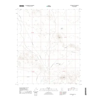
2018 Map of Nottbusch Butte
USGS Topo · Published 2018About this map
Nottbusch Butte rises as a prominent landmark above the arid expanse of the Palomas Plain in this 2018 survey of Yuma County. The terrain is defined by a series of isolated peaks and ridges, including the Clanton Hills and Deadman Mtn, which separate the flat basin from the rugged Gila Bend Mountains to the southeast. The landscape is marked by ephemeral drainage systems like Deadman Wash and Nottbusch Wash, illustrating the desert's hydrological patterns. Transport through this desolate region is limited to remote tracks such as Palomas Harquahala Rd and Arlington-Clanton Well Rd, which connect historical well sites and mining prospects across Nottbusch Valley and Apache Box. This map provides a clear record of the physical geography and sparse infrastructure in a region where the landforms dictate the few available routes.
Find a feature on this map
17 named features on this map. Tap any name to fly to it.
Don’t see what you’re looking for? This feature index may not catch every label — zoom into the map to look around manually.
Map Details
Editions of this 2018 Nottbusch Butte Map
This is the sole edition of this map. No revisions or reprints were ever made.
Other maps of this area

1927 · Hyder
USGS Topo · 1:62,500

1930 · Hyder
USGS Topo · 1:62,500

1942 · Vicksburg
USGS Topo · 1:250,000

1954 · Phoenix
USGS Topo · 1:250,000

1957 · Phoenix
USGS Topo · 1:250,000

1958 · Phoenix
USGS Topo · 1:250,000

1960 · Phoenix
USGS Topo · 1:250,000

1962 · Little Horn Mts
USGS Topo · 1:62,500

1962 · Eagletail Mts
USGS Topo · 1:62,500
1964 · Hyder NE
USGS Topo · 1:24,000