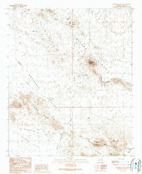
1990 Map of Nottbusch Butte
USGS Topo · Published 1990About this map
Cemetery Ridge and the Gila Bend Mountains dominate this arid landscape in Yuma County, illustrating a region defined by mining exploration and intermittent water sources. The map identifies numerous mining-related features, including the Big M Mine, the Yellow Breast Well, and several Mine Shafts and Adits scattered across the complex terrain. These labels point to a period of mineral prospecting that shaped the local history of the Nottbusch Valley. The presence of several Water Tanks and the namesake Nottbusch Butte underscore the importance of specific landmarks for navigation and survival in the Palomas Plain. To the west, the Clanton Hills are intersected by the Red Raven Road, while drainage patterns such as Deadman Wash and Nottbusch Wash trace the natural path of runoff through the Apache Box.
Find a feature on this map
19 named features on this map. Tap any name to fly to it.
Don’t see what you’re looking for? This feature index may not catch every label — zoom into the map to look around manually.
Map Details
Editions of this 1990 Nottbusch Butte Map
This is the sole edition of this map. No revisions or reprints were ever made.
Other maps of this area

1927 · Hyder
USGS Topo · 1:62,500

1930 · Hyder
USGS Topo · 1:62,500

1942 · Vicksburg
USGS Topo · 1:250,000

1954 · Phoenix
USGS Topo · 1:250,000

1957 · Phoenix
USGS Topo · 1:250,000

1958 · Phoenix
USGS Topo · 1:250,000

1960 · Phoenix
USGS Topo · 1:250,000

1962 · Little Horn Mts
USGS Topo · 1:62,500

1962 · Eagletail Mts
USGS Topo · 1:62,500
1964 · Hyder NE
USGS Topo · 1:24,000