
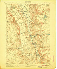
1912 Map of Number Four
USGS Topo · Published 1912About this map
Soft Maple Dam and the surrounding Adirondack wilderness define this landscape, surveyed by Frank Sutton and his team just after the first decade of the twentieth century. The map centers on the border between Herkimer and Lewis counties, capturing a region dominated by a dense network of glacial water bodies and meandering waterways. To the north, the Oswegatchie River and its namesake The Hogs Back terrain feature illustrate the complex drainage patterns of the northern woods. Further south, the terrain rises toward peaks like Stillwater Mtn and Mt Tom, interspersed with expansive lowlands such as Balsam Flats. This era reflects a period of early water management and timber-related geography, where remote ponds like Diana Pond and Gregg Lake remained largely isolated by the dense township boundaries of Watson, Croghan, and Webb.
Find a feature on this map
90 named features on this map. Tap any name to fly to it.
Don’t see what you’re looking for? This feature index may not catch every label — zoom into the map to look around manually.
Map Details
Editions of this 1912 Number Four Map
This is the sole edition of this map. No revisions or reprints were ever made.
Other maps of this area

1901 · Old Forge
USGS Topo · 1:62,500

1903 · Big Moose
USGS Topo · 1:62,500

1905 · Port Leyden
USGS Topo · 1:62,500
1907 · Port Leyden
USGS Topo · 1:62,500

1911 · Lowville
USGS Topo · 1:62,500

1912 · Mc Keever
USGS Topo · 1:62,500
1913 · Lowville
USGS Topo · 1:62,500

1913 · Lake Bonaparte
USGS Topo · 1:62,500
1915 · Number Four
USGS Topo · 1:62,500

1916 · Lake Bonaparte
USGS Topo · 1:62,500