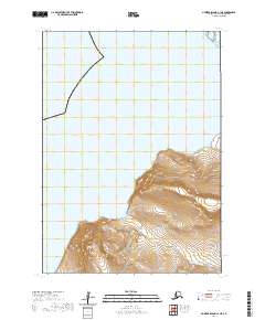
2020 Map of Nunivak Island C-1 NE
USGS Topo · Published 2020About this map
Killinupak Mtn rises from the southwestern landscape of this coastal Alaskan region, serving as the dominant topographic landmark in the southern interior of the quadrangle. The terrain here transitions from high ridges down toward the winding course of the Ikalugtulik River, which drains the tundra as it moves toward the sea. The map depicts a largely uninhabited expanse of the Bethel Census Area, defined by the Public Land Survey System grids of t8n r90w, t7n r90w, and t6n r90w. This 2020 record illustrates the persistent and undisturbed natural drainage patterns of the island before any modern infrastructure or settlement expanded into this specific sector.
Find a feature on this map
6 named features on this map. Tap any name to fly to it.
Don’t see what you’re looking for? This feature index may not catch every label — zoom into the map to look around manually.
Map Details
Editions of this 2020 Nunivak Island C-1 NE Map
This is the sole edition of this map. No revisions or reprints were ever made.
Other maps of this area

1951 · Nunivak Island
USGS Topo · 1:250,000

1951 · Baird Inlet
USGS Topo · 1:250,000

1954 · Nunivak Island
USGS Topo · 1:250,000

1954 · Baird Inlet
USGS Topo · 1:250,000

1954 · Baird Inlet C-8
USGS Topo · 1:63,360

1954 · Baird Inlet D-8
USGS Topo · 1:63,360
1954 · Nunivak Island D-1
USGS Topo · 1:63,360

1954 · Nunivak Island C-1
USGS Topo · 1:63,360

1958 · Nunivak Island
USGS Topo · 1:250,000

1964 · Nunivak Island
USGS Topo · 1:250,000