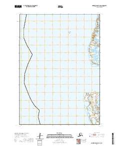
2020 Map of Nunivak Island D-1 SE
USGS Topo · Published 2020About this map
Nunivachak Island and the neighboring coastline of Kigigak Island anchor this coastal survey of the Bethel Census Area. The map details a remote maritime landscape where the waters of the Bering Sea meet the complex, fractured shorelines of these tidal islands. Further south, the northern edge of Nelson Island is visible, showing a landscape defined by intricate hydrography and wetland patterns rather than permanent settlements or road infrastructure. The survey is structured by the Public Land Survey System grids of t9n r89w and t8n r90w, reflecting how these isolated landmasses are managed and cataloged within the larger Alaskan wilderness.
Find a feature on this map
5 named features on this map. Tap any name to fly to it.
Don’t see what you’re looking for? This feature index may not catch every label — zoom into the map to look around manually.
Map Details
Editions of this 2020 Nunivak Island D-1 SE Map
This is the sole edition of this map. No revisions or reprints were ever made.
Other maps of this area

1951 · Nunivak Island
USGS Topo · 1:250,000

1951 · Baird Inlet
USGS Topo · 1:250,000

1954 · Nunivak Island
USGS Topo · 1:250,000

1954 · Baird Inlet
USGS Topo · 1:250,000

1954 · Baird Inlet C-8
USGS Topo · 1:63,360

1954 · Baird Inlet D-8
USGS Topo · 1:63,360
1954 · Nunivak Island D-1
USGS Topo · 1:63,360

1954 · Nunivak Island C-1
USGS Topo · 1:63,360

1958 · Nunivak Island
USGS Topo · 1:250,000

1964 · Nunivak Island
USGS Topo · 1:250,000