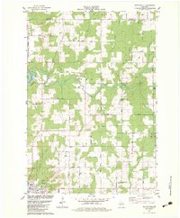
1982 Map of Nutterville
USGS Topo · Published 1983About this map
The Wisconsin River corridor dominates the western edge of this landscape, where the Chicago Milwaukee St Paul and Pacific railroad follows the riverbank. This rural expanse in Marathon County is defined by the convergence of the Trappe River and Little Trappe River, which feed into the primary waterway. Small agrarian communities like Nutterville and Schuett anchor the township of Texas, supported by local institutions such as St Peter Ch, Mission Ch, and the Mechanic Ridge Cem. The presence of numerous quarries and gravel pits throughout the quadrangle suggests a landscape heavily utilized for resource extraction alongside traditional farming. Further south, the suburban fringes of Wausau begin to appear, marked by infrastructure like a Radio Facility and Radar Road.
Find a feature on this map
39 named features on this map. Tap any name to fly to it.
Don’t see what you’re looking for? This feature index may not catch every label — zoom into the map to look around manually.
Map Details
Editions of this 1982 Nutterville Map
This is the sole edition of this map. No revisions or reprints were ever made.
Other maps of this area

1899 · Wausau
USGS Topo · 1:125,000

1902 · Wausau
USGS Topo · 1:125,000

1951 · Doering
USGS Topo · 1:48,000

1951 · Merrill
USGS Topo · 1:48,000

1953 · Wausau
USGS Topo · 1:48,000

1953 · Hatley
USGS Topo · 1:48,000

1954 · Iron Mountain
USGS Topo · 1:250,000

1955 · Green Bay
USGS Topo · 1:250,000

1959 · Iron Mountain
USGS Topo · 1:250,000

1963 · Wausau West
USGS Topo · 1:24,000