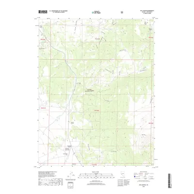
2018 Map of Nye Canyon
USGS Topo · Published 2018About this map
Toiyabe National Forest encompasses the high-altitude landscape of the Pine Grove Hills and the deep cuts of Nye Canyon, as documented in this 2018 survey. The terrain is marked by significant resource extraction and transportation infrastructure, including Cowboy Mine 2 and Cowboy Mine 1 near the northern boundary. Water management is evident through features like Wiley Ditch and numerous springs such as Garden Canyon Spring and Rye Grass Spring. To the south, the flatlands provide a stark contrast at Sweetwater Flat, which serves as a strategic point for the Sweetwater (US Marine Corps) Airport. This area represents a classic Great Basin intersection of military aviation, mining history, and managed forest land, linked by a complex network of trails including the Bald Mountain Trail and Sweet Peak Trail.
Find a feature on this map
42 named features on this map. Tap any name to fly to it.
Don’t see what you’re looking for? This feature index may not catch every label — zoom into the map to look around manually.
Map Details
Editions of this 2018 Nye Canyon Map
This is the sole edition of this map. No revisions or reprints were ever made.
Other maps of this area

1891 · Wellington
USGS Topo · 1:125,000

1893 · Wellington
USGS Topo · 1:125,000

1909 · Bridgeport
USGS Topo · 1:125,000

1911 · Bridgeport
USGS Topo · 1:125,000

1920 · Bridgeport
USGS Topo · 1:125,000

1948 · Walker Lake
USGS Topo · 1:250,000

1956 · Desert Creek Peak
USGS Topo · 1:62,500

1956 · Fales Hot Springs
USGS Topo · 1:62,500

1957 · Walker Lake
USGS Topo · 1:250,000
1958 · Bridgeport
USGS Topo · 1:62,500