
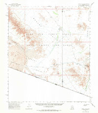
1965 Map of O'Neill Hills
USGS Topo · Published 1966About this map
O'Neills Grave stands as a solitary historical marker in the heart of this arid landscape, situated near O'Neill Pass between the O'Neill Hills and the Agua Dulce Mts. The terrain is defined by the historic track of the Camino Del Diablo, an arduous route crossing the Tule Desert and skirting the edge of the Pinacate Lava Flow. This 1960s survey captures the area when it was shared by the Cabeza Prieta Game Range and the Luke Air Force Range, highlighting a remote borderland where water sources like Papago Well and Dos Playas were essential for survival. Traces of human activity are sparse but notable, including the Papago Mine and Rasmussen Mine, which represent the difficult prospecting efforts along the United States-Mexico border.
Find a feature on this map
31 named features on this map. Tap any name to fly to it.
Don’t see what you’re looking for? This feature index may not catch every label — zoom into the map to look around manually.
Map Details
Editions of this 1965 O'Neill Hills Map
2 editions found
Other maps of this area

1953 · Ajo
USGS Topo · 1:250,000

1954 · Sonoyta
USGS Topo · 1:250,000

1957 · Ajo
USGS Topo · 1:250,000

1958 · Ajo
USGS Topo · 1:250,000

1962 · Ajo
USGS Topo · 1:250,000

1963 · Ajo
USGS Topo · 1:250,000

1963 · Quitobaquito Springs
USGS Topo · 1:62,500

1963 · Lukeville
USGS Topo · 1:250,000

1964 · Growler Peak
USGS Topo · 1:62,500
1964 · Agua Dulce Mts
USGS Topo · 1:62,500