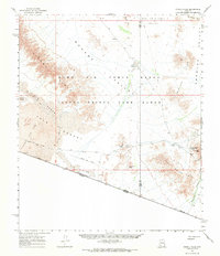
1965 Map of O'Neill Hills
USGS Topo · Published 1971About this map
The Camino Del Diablo winds through this arid section of the Sonoran Desert, tracing a path of historical survival along the international border with Sonora. The landscape is dominated by the overlapping boundaries of the Luke Air Force Range and the Cabeza Prieta Game Range, where the environment transitions from the Pinta Sands and Tule Lava Flow in the west to the O'Neill Hills and Agua Dulce Mts in the east. Scattered landmarks offer traces of early desert activity, including the lonely site of O'Neills Grave near O'Neill Pass and the isolated Dos Playas. Resource extraction is marked by the Papago Mine and Rasmussen Mine, while critical water sources like Papago Well and the ephemeral San Cristobal Wash define the limited infrastructure of this remote borderland.
Find a feature on this map
31 named features on this map. Tap any name to fly to it.
Don’t see what you’re looking for? This feature index may not catch every label — zoom into the map to look around manually.
Map Details
Editions of this 1965 O'Neill Hills Map
2 editions found

Other maps of this area

1953 · Ajo
USGS Topo · 1:250,000

1954 · Sonoyta
USGS Topo · 1:250,000

1957 · Ajo
USGS Topo · 1:250,000

1958 · Ajo
USGS Topo · 1:250,000

1962 · Ajo
USGS Topo · 1:250,000

1963 · Ajo
USGS Topo · 1:250,000

1963 · Quitobaquito Springs
USGS Topo · 1:62,500

1963 · Lukeville
USGS Topo · 1:250,000

1964 · Growler Peak
USGS Topo · 1:62,500
1964 · Agua Dulce Mts
USGS Topo · 1:62,500