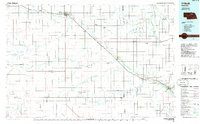
1985 Map of O'Neill
USGS Topo · Published 1985About this map
The Elkhorn River and its major tributaries, including the South Fork Elkhorn River and Cache Creek, define this 1980s landscape of north-central Nebraska. Centered on the city of O'Neill, the map documents a robust transportation and agricultural network supported by the Chicago and North Western and Burlington Northern railroads. These lines connect grain and cattle shipping hubs like Ewing, Clearwater, and Neligh. Beyond the river valleys, the terrain transitions into the distinct Buffalo Flats and the lake-dotted sandhills of the southwest, where Swan Lake and Lizard Lake sit near remote outposts like Amelia. This 1985 revision provides a detailed view of the regional infrastructure of the era, from the Perkins Memorial Airpark near Chambers to the Grove Lake State Wildlife Management Area, capturing the established rural community structure before modern consolidation.
Find a feature on this map
63 named features on this map. Tap any name to fly to it.
Don’t see what you’re looking for? This feature index may not catch every label — zoom into the map to look around manually.
Map Details
Editions of this 1985 O'Neill Map
2 editions found
Other maps of this area

1952 · Burwell NE
USGS Topo · 1:24,000

1954 · Atkinson SE
USGS Topo · 1:24,000

1954 · Atkinson
USGS Topo · 1:24,000

1954 · Stuart SE
USGS Topo · 1:24,000

1954 · Gables NW
USGS Topo · 1:24,000

1954 · Walnut
USGS Topo · 1:24,000

1954 · Dorsey SW
USGS Topo · 1:24,000

1954 · Bartlett NW
USGS Topo · 1:24,000

1954 · Opportunity
USGS Topo · 1:24,000

1954 · Meek SW
USGS Topo · 1:24,000