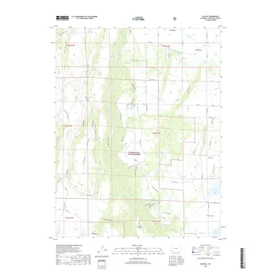
2019 Map of Oak Hill
USGS Topo · Published 2019About this map
Norwood sits at the northern edge of this high-altitude landscape, where the agricultural reaches of Wrights Mesa meet the canyons and forests of San Miguel County. The terrain is defined by the deep incision of Naturita Canyon and its tributaries, including McKee Draw and Burn Canyon, which cut through the uplifted plateaus. This 2019 survey documents a complex system of water management essential to the region's ranching history, featuring an extensive network of ditches such as the Gurley Ditch, Lily lands Canal, and the Hill and Tracey Lateral. Numerous small catchments and springs, from Sawmill Spring to the Old City Reservoir, provide vital water sources across the semi-arid flats. To the south, the boundary of the Uncompahgre National Forest marks a transition into more heavily timbered land, culminating at landmarks like Stockdale Point and the namesake Oak Hill.
Find a feature on this map
83 named features on this map. Tap any name to fly to it.
Don’t see what you’re looking for? This feature index may not catch every label — zoom into the map to look around manually.
Map Details
Editions of this 2019 Oak Hill Map
This is the sole edition of this map. No revisions or reprints were ever made.
Other maps of this area

1956 · Cortez
USGS Topo · 1:250,000

1956 · Moab
USGS Topo · 1:250,000

1958 · Cortez
USGS Topo · 1:250,000

1959 · Cortez
USGS Topo · 1:250,000

1959 · Moab
USGS Topo · 1:250,000

1960 · Moab
USGS Topo · 1:250,000

1962 · Moab
USGS Topo · 1:250,000

1962 · Cortez
USGS Topo · 1:250,000

1964 · Moab
USGS Topo · 1:250,000
1964 · Lone Cone
USGS Topo · 1:24,000