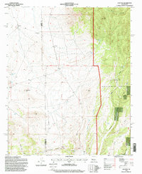
1995 Map of Oak Peak
USGS Topo · Published 1998About this map
Cibola National Forest encompasses the eastern half of this terrain, where the high point of Oak Peak overlooks a network of drainage canyons including Taylor Canyon and Baney Canyon. The landscape is defined by the high-desert necessity of water management, evidenced by numerous improved sources such as Deep Well Tank, Indian Tank, and Oak Springs Tank. On the western side of the Catron and Socorro County line, the land transitions toward ranching and mineral exploration markers. The presence of Lost Mines Hill suggests a history of prospecting, while the Ake Ranch and the isolated settlement at Frenchman point to a legacy of livestock operations in this arid corridor. Alamosa Creek provides the primary seasonal drainage for the central valley, cutting through the southern sections toward Sullivans Canyon.
Find a feature on this map
29 named features on this map. Tap any name to fly to it.
Don’t see what you’re looking for? This feature index may not catch every label — zoom into the map to look around manually.
Map Details
Editions of this 1995 Oak Peak Map
This is the sole edition of this map. No revisions or reprints were ever made.
Other maps of this area

1954 · Tularosa
USGS Topo · 1:250,000

1958 · Tularosa
USGS Topo · 1:250,000

1964 · Welty Hill
USGS Topo · 1:24,000

1964 · Bay Buck Peaks
USGS Topo · 1:24,000

1964 · Monica Saddle
USGS Topo · 1:24,000

1965 · Oak Peak
USGS Topo · 1:24,000
1965 · Kellog Well
USGS Topo · 1:24,000

1965 · Dusty
USGS Topo · 1:24,000

1979 · San Mateo Mountains
USGS Topo · 1:100,000
1981 · Luera Mountains East
USGS Topo · 1:24,000