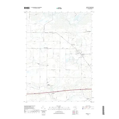
2019 Map of Oakfield
USGS Topo · Published 2019About this map
Oakfield serves as the primary hub in this Genesee County landscape, where the street grid converges at the intersection of Lewiston Rd and S Main St. The surrounding geography is defined by a complex network of wetlands and watercourses, including the expansive Oak Orchard Swamp to the north and the meandering Tonawanda Creek to the south. Local history is deeply etched into the land through numerous small burial grounds and landmarks like Nichols Hill and Limestone Ledge, which provide topographic variation among the fields.
Find a feature on this map
80 named features on this map. Tap any name to fly to it.
Don’t see what you’re looking for? This feature index may not catch every label — zoom into the map to look around manually.
Map Details
Editions of this 2019 Oakfield Map
This is the sole edition of this map. No revisions or reprints were ever made.
Other maps of this area

1897 · Albion
USGS Topo · 1:62,500

1897 · Medina
USGS Topo · 1:62,500

1904 · Batavia
USGS Topo · 1:62,500

1905 · Attica
USGS Topo · 1:62,500

1944 · Alexander
USGS Topo · 1:31,680

1944 · Albion
USGS Topo · 1:31,680

1949 · Attica
USGS Topo · 1:62,500

1949 · Alexander
USGS Topo · 1:24,000
1949 · Akron
USGS Topo · 1:24,000
1949 · Medina
USGS Topo · 1:24,000