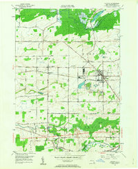
1950 Map of Oakfield
USGS Topo · Published 1963About this map
Oak Orchard State Game Refuge dominates the northern landscape, where Orchard Creek flows through the vast wetlands of Schmidt Marsh and Upper Stafford Marsh. This mid-century survey captures Genesee County during a period of transition, as the modern New York State Thruway cuts across the southern section of the map near North Pembroke. The established rail economy is still visible via the New York Central railroad passing through the village of Oakfield and the stop at Wheatville Sta.
Find a feature on this map
56 named features on this map. Tap any name to fly to it.
Don’t see what you’re looking for? This feature index may not catch every label — zoom into the map to look around manually.
Map Details
Editions of this 1950 Oakfield Map
This is the sole edition of this map. No revisions or reprints were ever made.
Other maps of this area

1897 · Albion
USGS Topo · 1:62,500

1897 · Medina
USGS Topo · 1:62,500

1904 · Batavia
USGS Topo · 1:62,500

1905 · Attica
USGS Topo · 1:62,500

1944 · Alexander
USGS Topo · 1:31,680

1944 · Albion
USGS Topo · 1:31,680

1949 · Attica
USGS Topo · 1:62,500

1949 · Alexander
USGS Topo · 1:24,000
1949 · Akron
USGS Topo · 1:24,000
1949 · Medina
USGS Topo · 1:24,000