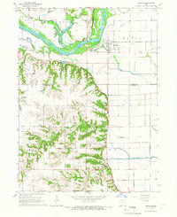
1965 Map of Oakville
USGS Topo · Published 1967About this map
The Iowa River dominates the northern landscape of this mid-1960s survey, where the river's winding path is flanked by a complex system of backwaters and oxbows including Spitznogle Lake, Sunfish Lake, and Halls Lake. South of the river, the terrain shifts from the floodplains into more dissected topography where Smith Creek and Hawkeye Creek have carved deep valleys. The settlement of Oakville serves as a focal point along the Chicago and North Western railroad line, while smaller rail-oriented locations like Elrick Junction mark the era's transport network.
Find a feature on this map
36 named features on this map. Tap any name to fly to it.
Don’t see what you’re looking for? This feature index may not catch every label — zoom into the map to look around manually.
Map Details
Editions of this 1965 Oakville Map
This is the sole edition of this map. No revisions or reprints were ever made.
Other maps of this area

1934 · Oquawka
USGS Topo · 1:48,000

1934 · Burlington
USGS Topo · 1:48,000

1935 · Keithsburg
USGS Topo · 1:48,000

1940 · Oquawka
USGS Topo · 1:62,500

1940 · Burlington
USGS Topo · 1:62,500

1941 · Keithsburg
USGS Topo · 1:62,500

1946 · Wapello
USGS Topo · 1:62,500

1949 · Wapello
USGS Topo · 1:62,500

1953 · Toolesboro
USGS Topo · 1:24,000
1953 · Joy
USGS Topo · 1:24,000