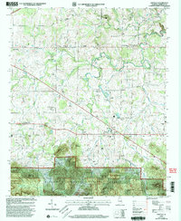
2000 Map of Oakville
USGS Topo · Published 2003About this map
Oakville and its surrounding rural communities in Lawrence County are documented here through their ancestral landmarks and complex terrain. The landscape is defined by the headwaters of Flint Creek and its many tributaries like West Flint Creek and McDaniel Creek, which carve through the northern edges of the William B Bankhead National Forest. Significant local history is preserved in the numerous family cemeteries and country churches that dot the countryside, including Moody Cem, Speake Cem, and the Aldridge Grove Ch.
Find a feature on this map
81 named features on this map. Tap any name to fly to it.
Don’t see what you’re looking for? This feature index may not catch every label — zoom into the map to look around manually.
Map Details
Editions of this 2000 Oakville Map
This is the sole edition of this map. No revisions or reprints were ever made.
Other maps of this area

1935 · Moulton
USGS Topo · 1:24,000

1935 · Upshaw
USGS Topo · 1:24,000

1935 · Danville
USGS Topo · 1:48,000

1935 · Oakville
USGS Topo · 1:24,000

1936 · Caddo
USGS Topo · 1:24,000

1936 · Mc Kendry
USGS Topo · 1:24,000

1936 · Trinity
USGS Topo · 1:24,000

1936 · Moulton
USGS Topo · 1:48,000

1936 · Masterson
USGS Topo · 1:24,000

1936 · Stroups Crossroads
USGS Topo · 1:24,000