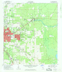
1967 Map of Ocala East
USGS Topo · Published 1969About this map
Silver Springs serves as a focal point for this late-1960s landscape, where the Silver River begins its eastward flow toward the massive Marshall Swamp. The map documents a period of significant regional transformation, most notably the path of the Proposed Cross Florida Barge Canal cutting through the southern half of the quadrangle alongside the existing Seaboard Coast Line railroad.
Find a feature on this map
50 named features on this map. Tap any name to fly to it.
Don’t see what you’re looking for? This feature index may not catch every label — zoom into the map to look around manually.
Map Details
Editions of this 1967 Ocala East Map
This is the sole edition of this map. No revisions or reprints were ever made.
Other maps of this area

1893 · Citra
USGS Topo · 1:62,500

1895 · Citra
USGS Topo · 1:62,500

1895 · Ocala
USGS Topo · 1:62,500

1954 · Gainesville
USGS Topo · 1:250,000

1954 · Daytona Beach
USGS Topo · 1:250,000

1958 · Daytona Beach
USGS Topo · 1:250,000

1958 · Gainesville
USGS Topo · 1:250,000

1959 · Gainesville
USGS Topo · 1:250,000

1964 · Daytona Beach
USGS Topo · 1:250,000
1967 · Belleview
USGS Topo · 1:24,000