1967 Map of Belleview
USGS Topo · Published 1969About this map
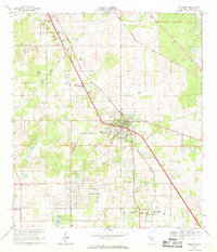
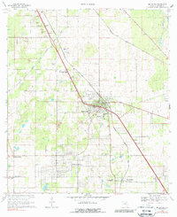
Belleview and the nearby grid of Belleview Heights define this Central Florida landscape during a period of infrastructure anticipation. The prominent diagonal of the Proposed Cross Florida Barge Canal cuts through the terrain, intersecting the Seaboard Coast Line railroad near Santos. This ambitious engineering project, though later halted, is a central feature of the 1960s landscape, alongside numerous limestone quarries and sandpits that speak to the local extractive industry.
Find a feature on this map
35 named features on this map. Tap any name to fly to it.
Don’t see what you’re looking for? This feature index may not catch every label — zoom into the map to look around manually.
Map Details
Editions of this 1967 Belleview Map
2 editions found
Other maps of this area

1893 · Panasoffkee
USGS Topo · 1:62,500

1895 · Panasoffkee
USGS Topo · 1:62,500

1895 · Ocala
USGS Topo · 1:62,500

1954 · Gainesville
USGS Topo · 1:250,000

1954 · Daytona Beach
USGS Topo · 1:250,000

1955 · Plant City
USGS Topo · 1:250,000

1955 · Orlando
USGS Topo · 1:250,000

1957 · Orlando
USGS Topo · 1:250,000

1958 · Orlando
USGS Topo · 1:250,000

1958 · Daytona Beach
USGS Topo · 1:250,000