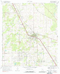
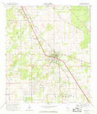
1967 Map of Belleview
USGS Topo · Published 1988About this map
Belleview serves as the central hub of this mid-century Florida landscape, defined by the industrial presence of the Seaboard Coast Line and a patchwork of local quarries. To the north, the Proposed Cross Florida Barge Canal cuts a distinct path through the terrain near Santos, reflecting a major infrastructure project of the era. The mapping details numerous small religious and community landmarks, including New Jerusalem Ch, St Pauls Ch, and the Belleview-Santos High Sch.
Find a feature on this map
39 named features on this map. Tap any name to fly to it.
Don’t see what you’re looking for? This feature index may not catch every label — zoom into the map to look around manually.
Map Details
Editions of this 1967 Belleview Map
2 editions found
Other maps of this area

1893 · Panasoffkee
USGS Topo · 1:62,500

1895 · Panasoffkee
USGS Topo · 1:62,500

1895 · Ocala
USGS Topo · 1:62,500

1954 · Gainesville
USGS Topo · 1:250,000

1954 · Daytona Beach
USGS Topo · 1:250,000

1955 · Plant City
USGS Topo · 1:250,000

1955 · Orlando
USGS Topo · 1:250,000

1957 · Orlando
USGS Topo · 1:250,000

1958 · Orlando
USGS Topo · 1:250,000

1958 · Daytona Beach
USGS Topo · 1:250,000