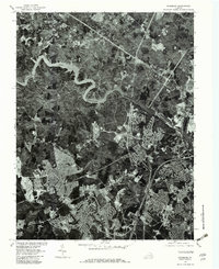
1977 Map of Occoquan
USGS Topo · Published 1982About this map
The Occoquan River and its massive Occoquan Reservoir dominate this aerial survey, illustrating the complex intersection of natural drainage and rapid suburban expansion in Prince William County. The 1977 photoimagery reveals the intricate street patterns of growing residential hubs like Dale City and Woodbridge, which contrast sharply with the winding, wooded banks of Sandy Run. This orthophotoquad is particularly revealing for local historians, as it shows the physical footprint of late-1970s development alongside established community nodes such as Farrs Corner and Agnewville. The transition from rural forest to dense neighborhood is starkly visible, especially near the shores of Lake Omiscol, providing a precise record of the landscape before further modern densification.
Find a feature on this map
8 named features on this map. Tap any name to fly to it.
Don’t see what you’re looking for? This feature index may not catch every label — zoom into the map to look around manually.
Map Details
Editions of this 1977 Occoquan Map
This is the sole edition of this map. No revisions or reprints were ever made.
Other maps of this area

1890 · Mt. Vernon
USGS Topo · 1:125,000

1891 · Mt. Vernon
USGS Topo · 1:125,000

1894 · Mt. Vernon
USGS Topo · 1:125,000

1897 · Mt. Vernon
USGS Topo · 1:125,000

1900 · Washington
USGS Topo · 1:62,500

1913 · Indian Head
USGS Topo · 1:62,500

1915 · Fairfax
USGS Topo · 1:62,500

1923 · Indian Head
USGS Topo · 1:48,000

1925 · Indian Head
USGS Topo · 1:62,500

1927 · Quantico
USGS Topo · 1:62,500