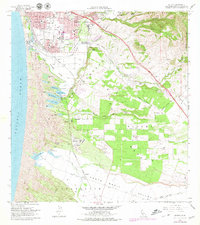
1979 Map of Oceano
USGS Topo · Published 1979About this map
Coastal dunes and agricultural valleys characterize this late-1970s landscape, where the Southern Pacific railroad corridor links the developing communities of Grover City and Oceano. The map reveals a complex hydrographic system between the shoreline and the Nipomo Mesa, featuring a string of smaller water bodies such as Oso Flaco Lake, Celery Lake, and Black Lake. These lakes are caught in the shifting sands of the extensive Sand Dunes that dominate the western edge of the quadrangle.
Find a feature on this map
58 named features on this map. Tap any name to fly to it.
Don’t see what you’re looking for? This feature index may not catch every label — zoom into the map to look around manually.
Map Details
Editions of this 1979 Oceano Map
This is the sole edition of this map. No revisions or reprints were ever made.
Other maps of this area

1897 · Arroyo Grande
USGS Topo · 1:62,500

1900 · San Luis
USGS Topo · 1:125,000

1905 · Guadalupe
USGS Topo · 1:125,000

1905 · Lompoc
USGS Topo · 1:125,000

1922 · Nipomo
USGS Topo · 1:62,500

1942 · Guadalupe
USGS Topo · 1:125,000

1942 · Lompoc
USGS Topo · 1:125,000

1942 · Arroyo Grande
USGS Topo · 1:62,500

1942 · Santa Maria
USGS Topo · 1:62,500

1942 · Point Sal
USGS Topo · 1:62,500