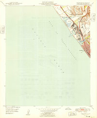
1949 Map of Oceanside
USGS Topo · Published 1949About this map
Military infrastructure and coastal transit dominate the landscape of North County San Diego in the late 1940s. The massive footprint of Camp Pendleton and the Naval Reservation occupies the northern half of the quadrangle, where specialized sites like Camp Del Mar sit adjacent to the Gulf of Santa Catalina. The logistics of the era are clearly defined by the parallel paths of the Atchison Topeka and Santa Fe railroad and the Coast Highway, which funnel traffic toward the growing city of Oceanside. Between the major drainage systems of the Santa Margarita River and the San Luis Rey River, industrial extraction is evident at a Gravel Pit and Quarry. This map captures a pivotal moment when wartime installations were becoming permanent fixtures of the Southern California coastline.
Find a feature on this map
19 named features on this map. Tap any name to fly to it.
Don’t see what you’re looking for? This feature index may not catch every label — zoom into the map to look around manually.
Map Details
Editions of this 1949 Oceanside Map
This is the sole edition of this map. No revisions or reprints were ever made.
Other maps of this area

1893 · Oceanside
USGS Topo · 1:62,500

1898 · Oceanside
USGS Topo · 1:62,500

1901 · Oceanside
USGS Topo · 1:62,500

1901 · San Luis Rey
USGS Topo · 1:125,000

1902 · Capistrano
USGS Topo · 1:125,000

1904 · Southern California Sheet No. 2
USGS Topo · 1:250,000

1906 · Capistrano
USGS Topo · 1:125,000

1941 · Margarita Peak
USGS Topo · 1:62,500

1942 · Margarita Peak
USGS Topo · 1:62,500

1942 · San Juan Capistrano
USGS Topo · 1:62,500