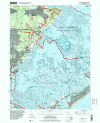
1995 Map of Oceanville
USGS Topo · Published 2000About this map
Smithville and Leeds Point anchor the northern reaches of this coastal landscape, where the transition from upland settlements to tidal salt marshes is sharply defined. The area is dominated by the Edwin B Forsythe National Wildlife Refuge and the Absecon State Wildlife Management Areas, preserving a vast network of waterways including Reeds Bay and the intricate Sloop Thorofare.
Find a feature on this map
74 named features on this map. Tap any name to fly to it.
Don’t see what you’re looking for? This feature index may not catch every label — zoom into the map to look around manually.
Map Details
Editions of this 1995 Oceanville Map
This is the sole edition of this map. No revisions or reprints were ever made.
Other maps of this area

1887 · Atlantic City
USGS Topo · 1:62,500

1888 · Little Egg Harbor
USGS Topo · 1:62,500

1890 · Great Egg Harbor
USGS Topo · 1:62,500

1890 · Mullica
USGS Topo · 1:62,500

1893 · Great Egg Harbor
USGS Topo · 1:62,500

1893 · Little Egg Harbor
USGS Topo · 1:62,500

1894 · Atlantic City
USGS Topo · 1:62,500

1894 · Mullica
USGS Topo · 1:62,500

1898 · Mullica
USGS Topo · 1:62,500

1900 · Rancocas
USGS Topo · 1:125,000
Featured Places
- Egg Harbor Township, NJ
- Atlantic City, NJ
- Galloway Township, NJ
- Little Egg Harbor Township, NJ
- Pleasantville, NJ