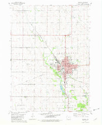
1981 Map of Oelwein
USGS Topo · Published 1982About this map
Oelwein serves as the focal point of this 1980s Iowa landscape, where the confluence of agriculture and industry is visible in the dense rail network and surrounding rural townships. The Chicago and North Western railroad corridors dominate the local geography, threading through the city and out into the productive farmland of Fremont and Jefferson townships. The map documents a significant community infrastructure, including the Oelwein Municipal Airport and several localized school districts such as Harlan Sch and Southside Sch.
Find a feature on this map
52 named features on this map. Tap any name to fly to it.
Don’t see what you’re looking for? This feature index may not catch every label — zoom into the map to look around manually.
Map Details
Editions of this 1981 Oelwein Map
This is the sole edition of this map. No revisions or reprints were ever made.
Other maps of this area

1901 · Oelwein
USGS Topo · 1:125,000

1954 · Waterloo
USGS Topo · 1:250,000

1955 · Waterloo
USGS Topo · 1:250,000

1959 · Dubuque
USGS Topo · 1:250,000

1961 · Dubuque
USGS Topo · 1:250,000

1962 · Dubuque
USGS Topo · 1:250,000

1971 · Sumner
USGS Topo · 1:24,000

1971 · Fairbank
USGS Topo · 1:24,000

1971 · Littleton
USGS Topo · 1:24,000

1976 · Dubuque
USGS Topo · 1:250,000