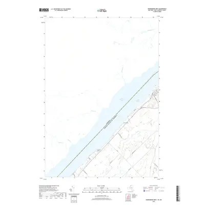
2019 Map of Ogdensburg West
USGS Topo · Published 2019About this map
The Saint Lawrence River serves as the international boundary between the United States and Canada, defining the geography of this northern New York borderland. Along the southern shore, prominent landmarks like Nevins Point and Stillwells Point define the coastline, while a network of rural roads such as Stone Church Rd and Monkey Hill Rd weave through the inland terrain. The area is marked by numerous small tributaries flowing toward the river, including Bradleys Cr, Smades Cr, and Wells Cr. To the northeast, the outskirts of Ogdensburg show a burgeoning grid of residential streets including Renselaer Ave and Ogden St, contrasting with the more rural southern reaches near Lost Village Rd. This mapping reflects a modern era of precise geospatial data, documenting the contemporary relationship between this riverfront community and its natural watercourses like Johnstown Cr.
Find a feature on this map
26 named features on this map. Tap any name to fly to it.
Don’t see what you’re looking for? This feature index may not catch every label — zoom into the map to look around manually.
Map Details
Editions of this 2019 Ogdensburg West Map
This is the sole edition of this map. No revisions or reprints were ever made.
Other maps of this area

1904 · Lisbon
USGS Topo · 1:48,000

1904 · Ogdensburg
USGS Topo · 1:62,500

1905 · Ogdensburg
USGS Topo · 1:62,500

1906 · Brier Hill
USGS Topo · 1:62,500

1906 · Red Mills
USGS Topo · 1:62,500

1942 · Morristown
USGS Topo · 1:24,000

1943 · Ogdensburg East
USGS Topo · 1:31,680

1943 · Morristown
USGS Topo · 1:31,680
1943 · Red Mills
USGS Topo · 1:31,680

1943 · Edwardsville
USGS Topo · 1:31,680