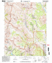
2001 Map of Oh-Be-Joyful
USGS Topo · Published 2004About this map
Mining heritage and alpine wilderness converge in this detailed record of the high country north of Crested Butte. The Slate River and East River valleys anchor a landscape defined by dramatic peaks like Gothic Mountain and Mount Emmons. Historical industrial activity is etched into the terrain, from the Pittsburg Mine in Poverty Gulch to the Painter Boy Mine near Elkton. These scattered sites, along with the Augusta Mine beneath Augusta Mountain, recall the late 19th-century silver and coal booms that shaped the Gunnison region.
Find a feature on this map
79 named features on this map. Tap any name to fly to it.
Don’t see what you’re looking for? This feature index may not catch every label — zoom into the map to look around manually.
Map Details
Editions of this 2001 Oh-Be-Joyful Map
This is the sole edition of this map. No revisions or reprints were ever made.
Other maps of this area

1888 · Crested Butte
USGS Topo · 1:62,500

1888 · Anthracite
USGS Topo · 1:62,500

1889 · Crested Butte
USGS Topo · 1:62,500

1889 · Anthracite
USGS Topo · 1:62,500

1893 · Anthracite
USGS Topo · 1:62,500

1893 · Crested Butte
USGS Topo · 1:62,500

1893 · Aspen
USGS Topo · 1:62,500

1894 · Anthracite
USGS Topo · 1:62,500

1895 · Aspen
USGS Topo · 1:62,500

1909 · Mount Jackson
USGS Topo · 1:125,000