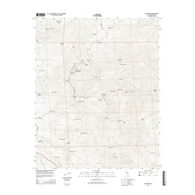
2015 Map of Oiler Peak
USGS Topo · Published 2015About this map
Oiler Peak stands as the central landmark in this 2015 survey of the southern Sierra Nevada foothills in Kern County. The map documents a landscape defined by sharp drainage systems and a series of spring-fed flats, including Fence Camp Flat, Rhymes Flat, and Dougherty Flat. The settlement patterns here follow the winding course of the Caliente Creek drainage, where the small communities of Caliente and Bealville sit at the edge of the mountains. Notable for local historians is the Fig Orchard located south of Harper Canyon, an indication of agricultural land use in this otherwise arid, dissected terrain. The complex network of springs, such as Earthquake Spring and Woodchopper Spring, illustrates the critical water sources that once supported travel and ranching through these canyons. High-elevation points like Centennial Ridge and Manzanita Ridge offer a clear picture of the area's geological structure as it transitions into the Tehachapi region.
Find a feature on this map
104 named features on this map. Tap any name to fly to it.
Don’t see what you’re looking for? This feature index may not catch every label — zoom into the map to look around manually.
Map Details
Editions of this 2015 Oiler Peak Map
This is the sole edition of this map. No revisions or reprints were ever made.
Other maps of this area
1914 · Caliente
USGS Topo · 1:125,000
1915 · Mojave
USGS Topo · 1:125,000
1929 · Bena
USGS Topo · 1:31,680
1930 · Bear Mountain
USGS Topo · 1:31,680
1932 · Bena
USGS Topo · 1:31,680
1933 · Bear Mountain
USGS Topo · 1:31,680
1943 · Tehachapi
USGS Topo · 1:62,500
1943 · Emerald Mtn
USGS Topo · 1:62,500
1943 · Cummings Mountain
USGS Topo · 1:62,500
1943 · Breckenridge Mountain
USGS Topo · 1:62,500