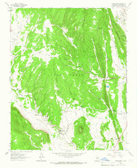
1961 Map of Ojitos Frios
USGS Topo · Published 1966About this map
Ojitos Frios (Gabaldon PO) and the neighboring settlement of La Manga anchor this high-altitude landscape in San Miguel County, recorded just before the mid-1960s. The map illustrates a transitional zone where the sharp ridge of The Creston gives way to the lower grazing lands and drainage basins of Tecolote Creek and Ojitos Frios Creek. Local life is centered around family-named agricultural holdings such as Box Ranch, Forest Ranch, and Ojitos Frios Ranch, alongside the Santo Niño Ch and an adjacent Cem. The topography is dominated by the prominent volcanic profile of Tecolote Peak to the south. Notable infrastructure of the era include a Gaging Sta along the creek and a Stadium located near Maximiliano Luna, indicating a pocket of established community development within the rugged New Mexican terrain.
Find a feature on this map
30 named features on this map. Tap any name to fly to it.
Don’t see what you’re looking for? This feature index may not catch every label — zoom into the map to look around manually.
Map Details
Editions of this 1961 Ojitos Frios Map
This is the sole edition of this map. No revisions or reprints were ever made.
Other maps of this area

1889 · Las Vegas
USGS Topo · 1:125,000

1890 · Bernal
USGS Topo · 1:125,000

1891 · Bernal
USGS Topo · 1:125,000

1891 · Las Vegas
USGS Topo · 1:125,000

1893 · Las Vegas
USGS Topo · 1:125,000

1894 · Bernal
USGS Topo · 1:125,000

1954 · Santa Fe
USGS Topo · 1:250,000

1958 · Santa Fe
USGS Topo · 1:250,000

1960 · Villanueva
USGS Topo · 1:62,500

1960 · Apache Springs
USGS Topo · 1:62,500