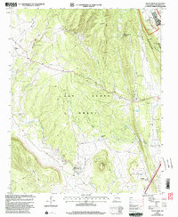
2002 Map of Ojitos Frios
USGS Topo · Published 2003About this map
The Las Vegas Grant landscape of San Miguel County is defined by a network of ranching outposts and high-desert drainage systems as they appeared at the start of the 21st century. The settlement at Ojitos Frios, also known as Gabaldon PO, serves as a primary point of interest for genealogists tracing local family roots. Further south, the community of La Manga is centered around the Santo Niño Ch and an adjacent Cem, reflecting the traditional importance of these religious and civic hubs in northern New Mexico.
Find a feature on this map
30 named features on this map. Tap any name to fly to it.
Don’t see what you’re looking for? This feature index may not catch every label — zoom into the map to look around manually.
Map Details
Editions of this 2002 Ojitos Frios Map
This is the sole edition of this map. No revisions or reprints were ever made.
Other maps of this area

1889 · Las Vegas
USGS Topo · 1:125,000

1890 · Bernal
USGS Topo · 1:125,000

1891 · Bernal
USGS Topo · 1:125,000

1891 · Las Vegas
USGS Topo · 1:125,000

1893 · Las Vegas
USGS Topo · 1:125,000

1894 · Bernal
USGS Topo · 1:125,000

1954 · Santa Fe
USGS Topo · 1:250,000

1958 · Santa Fe
USGS Topo · 1:250,000

1960 · Villanueva
USGS Topo · 1:62,500

1960 · Apache Springs
USGS Topo · 1:62,500