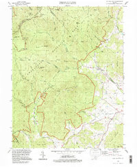
1994 Map of Old Rag Mountain
USGS Topo · Published 1997About this map
Old Rag Mountain dominates this mid-1990s landscape, serving as a focal point for the surrounding highlands of the Shenandoah National Park. The survey reflects a region defined by high-elevation wilderness and the historical traces of mountain life, notably the Corbin Cabin and the network of trails like the Nicholson Hollow Trail and Appalachian Trail. In the valleys below the Blue Ridge, small rural communities such as Nethers and Etlan persist along the winding courses of the Hughes River and Robinson River. Local genealogy and social history are centered on the Bethlehem Ch and Etlan Ch, alongside scattered family burial grounds. The map provides a clear look at the infrastructure of forest management through the Pinnacle Ranger Station and various shelters like Shaver Hollow Shelter, mapping the transition from the protected peaks of Stony Man to the agricultural reaches of eastern Madison County.
Find a feature on this map
66 named features on this map. Tap any name to fly to it.
Don’t see what you’re looking for? This feature index may not catch every label — zoom into the map to look around manually.
Map Details
Editions of this 1994 Old Rag Mountain Map
This is the sole edition of this map. No revisions or reprints were ever made.
Other maps of this area

1892 · Gordonsville
USGS Topo · 1:125,000

1893 · Luray
USGS Topo · 1:125,000

1905 · Luray
USGS Topo · 1:125,000

1929 · Stony Man
USGS Topo · 1:48,000

1930 · Madison
USGS Topo · 1:48,000

1933 · Stony Man
USGS Topo · 1:62,500

1933 · Madison
USGS Topo · 1:62,500

1949 · Charlottesville
USGS Topo · 1:250,000

1956 · Charlottesville
USGS Topo · 1:250,000

1961 · Sperryville
USGS Topo · 1:62,500