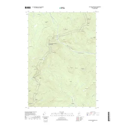
2018 Map of Old Speck Mountain
USGS Topo · Published 2018About this map
Old Speck Mtn dominates this portion of the Mahoosuc Range, serving as a centerpiece for a landscape defined by significant elevation changes and glacial geography. The Appalachian National Scenic Trail winds through the center of the sheet, connecting several prominent peaks including Baldpate Mtn, Mahoosuc Mtn, and Goose Eye Mtn. The small settlement of Ketchum sits at the southern edge of the terrain where the Bull Branch meets the Sunday River. Dramatic geological features are visible along the Bear River corridor, notably Grafton Notch and the steep descents at Screw Auger Falls Gorge and Mother Walker Falls Gorge. The map records a complex network of water systems, from high-altitude features like Speck Pond to the narrow passages of Mahoosuc Notch, illustrating the drainage patterns that have shaped these New England highlands.
Find a feature on this map
54 named features on this map. Tap any name to fly to it.
Don’t see what you’re looking for? This feature index may not catch every label — zoom into the map to look around manually.
Map Details
Editions of this 2018 Old Speck Mountain Map
This is the sole edition of this map. No revisions or reprints were ever made.
Other maps of this area

1893 · Gorham
USGS Topo · 1:62,500

1896 · Gorham
USGS Topo · 1:62,500

1914 · Bethel
USGS Topo · 1:62,500

1930 · Milan
USGS Topo · 1:62,500

1933 · Milan
USGS Topo · 1:62,500

1934 · Milan
USGS Topo · 1:62,500

1937 · Gorham
USGS Topo · 1:48,000

1940 · Bethel
USGS Topo · 1:62,500

1941 · Bethel
USGS Topo · 1:62,500

1942 · Gorham
USGS Topo · 1:62,500
Featured Places
- Newry, ME
- Ketchum, Riley Township
- Grafton Township, ME
- Andover West Surplus Township, ME
- Riley Township, ME